Individual undergraduate graduation project · Gwadar, Pakistan · Beijing Forestry University · 2022
Planning and Design of a New Waterfront District through a Smart City Lens
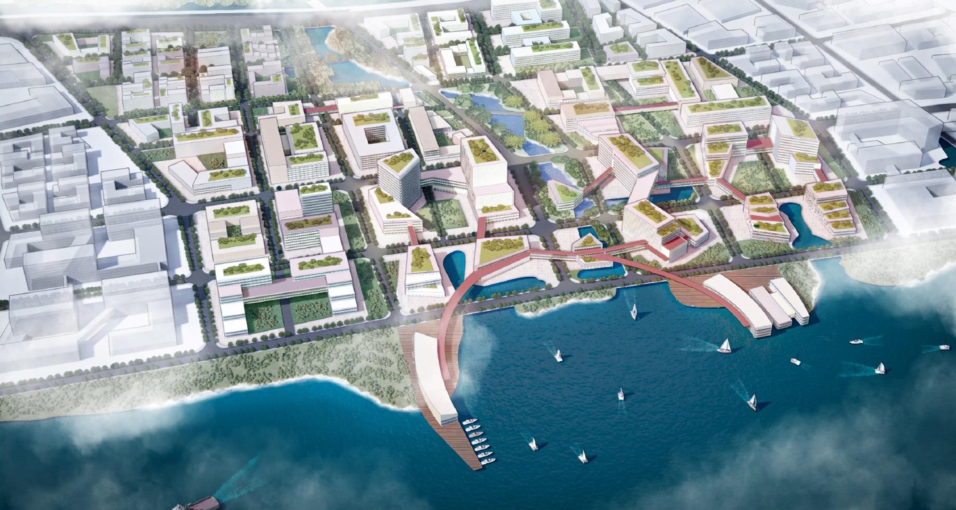
An undergraduate planning project for an approximately 125-hectare waterfront district in the Gwadar Free Zone, Pakistan. The proposal integrates smart infrastructure, a blue-green network, mixed-use districts, and multi-level mobility into one spatial framework.
01
Overview
Context and purpose
Structured around a smart innovation park, a green and liveable district, and an open waterfront landscape, the project moves from regional and site analysis to a coordinated masterplan, land-use framework, mobility and landscape systems, development controls, and spatial visualizations. Its value lies not in claiming technological implementation, but in showing how industrial growth, everyday life, ecology, and infrastructure can be translated into a coherent spatial proposition.
My contribution
What I was responsible for
- 01
Translated regional strategy, the free-zone masterplan, site boundaries, and environmental conditions into a design brief for an approximately 125-hectare waterfront district.
- 02
Used site analysis and SWOT to connect weak industrial and transport foundations with water scarcity, coastal risk, ecological assets, and wider locational opportunities.
- 03
Developed a three-part framework—innovation park, liveable district, and open waterfront—guided by people-centred planning, connectivity, resilience, and site responsiveness.
- 04
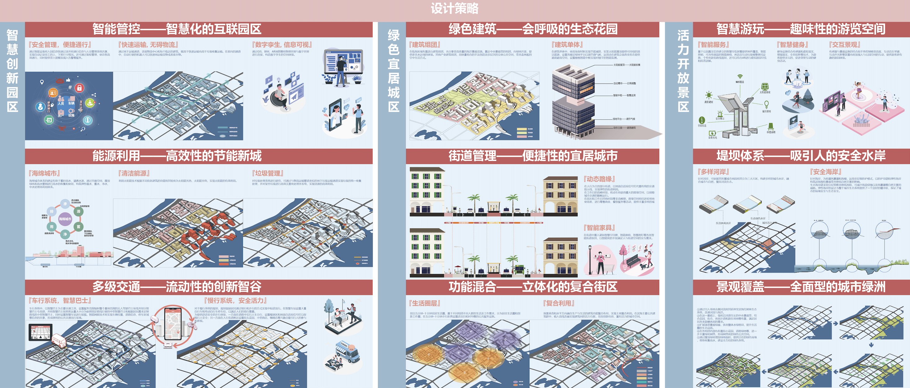
Coordinated smart management, water and energy systems, public transport, walking and cycling, mixed use, coastal protection, and landscape infrastructure across scales.
- 05
Produced the masterplan, land-use and road systems, landscape network, development intensity, building-height controls, and spatial visualizations.
- 06
Communicated the project through a 53-page defence deck and a comprehensive graduation exhibition board.
02
Process & evidence
Background: A waterfront district within an emerging port city
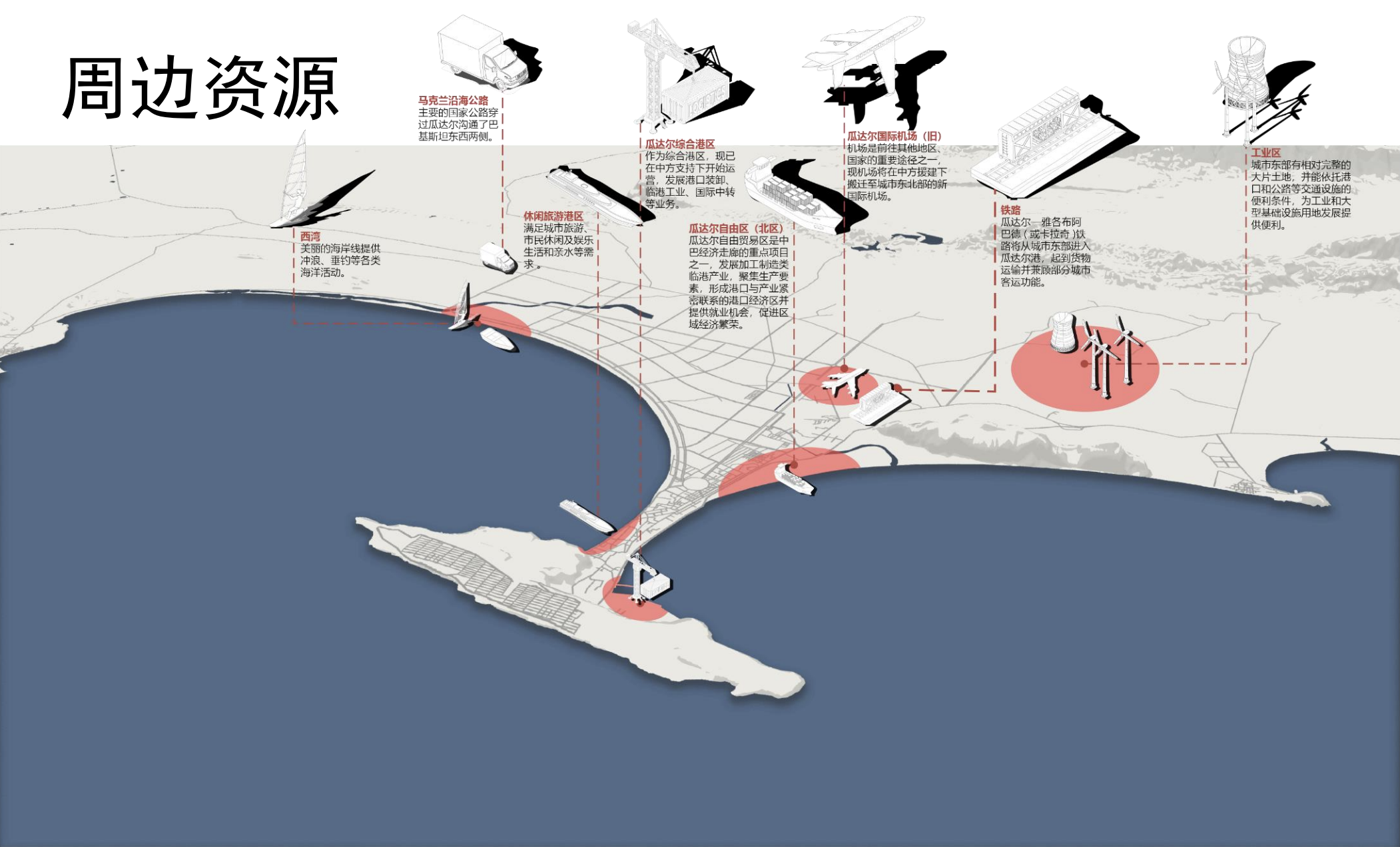
This 2022 undergraduate graduation project in Urban and Rural Planning at Beijing Forestry University focuses on a waterfront site in the northern part of the Gwadar Free Zone, Pakistan. The source material situates Gwadar within the wider context of the China–Pakistan Economic Corridor, port development, and regional trade. At the city scale, planned industrial growth is concentrated in the east while housing and services expand westward; the project site sits where this eastern production zone meets the East Bay coastline. Covering approximately 125 hectares, it is bounded by the East Bay Expressway to the west, the bay to the southeast, and planned urban roads to the north and south. The surrounding masterplan allocates medical-device and light-industrial parks alongside a comprehensive service and leisure district, creating a design brief that must reconcile employment, daily life, and public waterfront space.
03
Process & evidence
Question and challenge: How can growth, everyday life, and coastal risk coexist?
The site combines significant opportunity with substantial constraints. Its port location, coastal landscape, and anticipated industrial demand are countered by largely undeveloped coastal flats and desert, poor road conditions, limited public transport and green space, and a relatively weak industrial base. Environmental conditions add another layer of difficulty: a hot desert climate brings persistent water scarcity and heat; seasonal winds and large summer waves make coastal safety a serious planning concern; and habitats such as tidal wetlands, coral reefs, and coastal dunes mean that development cannot be assessed through construction capacity alone. The project therefore asks a broader question than how to “build a smart city”: how can an infrastructure-poor coastal district support industrial efficiency, convenient daily life, resource cycles, ecological continuity, and hazard resilience at the same time?
04
Process & evidence
Research and process: Translating multi-scalar evidence into a design brief
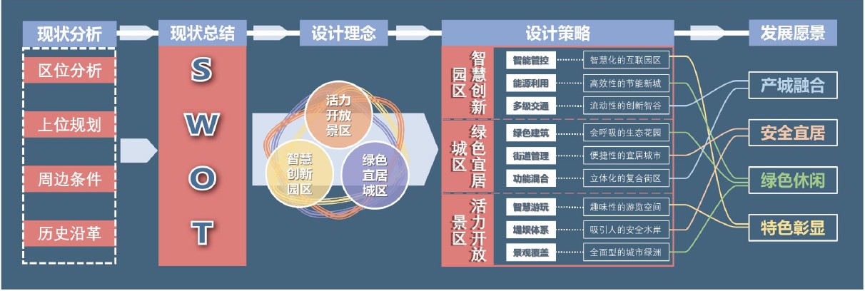
The research moves from macro-scale location and regional connections through industrial and transport relationships to the site boundary, existing land use, and environmental conditions. At the regional scale, I mapped the relationships between the port, free zone, airport, and major roads. At the site scale, I brought industry, mobility, waterfront space, ecosystems, climate, topography, and marine conditions into a shared analytical frame. Reading these findings against the higher-level masterplan clarified the need to accommodate medical-device and light-industrial development alongside services, leisure, and everyday life. The site summary and SWOT established four principles—people-centred planning, smart connectivity, safety and resilience, and responsiveness to local conditions. The design then progressed from existing-condition analysis to synthesis, concept, strategies, and a wider development vision.
05
Process & evidence
Key decision: Using park, district, and waterfront as an organising framework
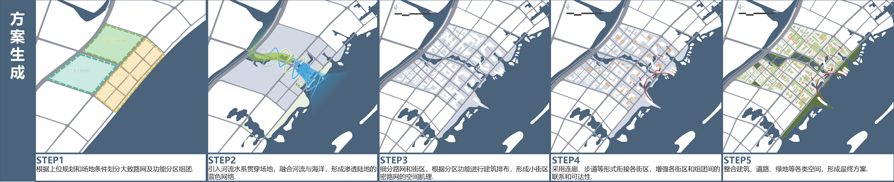
The project’s central design decision was to translate the broad idea of a smart city into three interconnected urban roles. The smart innovation park concentrates on industrial operations, logistics, energy, and mobility; the green and liveable district addresses building clusters, streets, daily-life catchments, and mixed use; and the open waterfront focuses on public experience, ecological networks, and coastal safety. These are not isolated zones, but overlapping systems connected through shared public space and infrastructure. The resulting structure is described as “one ring, one corridor, three districts, and three belts”: an active smart-city ring links major public spaces, while a coastal promenade frames the waterfront; medical-device, light-industrial, and comprehensive service districts form the three principal areas; and landscape, innovation, and liveability belts connect ecology, research and development, production, and everyday life.
06
Process & evidence
Land-use framework: Combining production, services, living, and open space
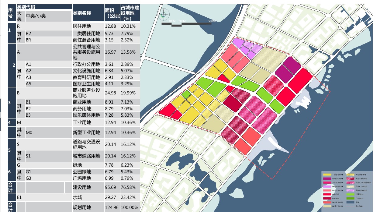
Construction land accounts for 957,071 square metres, or 76.58% of the planning area, while water covers 292,565 square metres, or 23.42%. The land-use framework combines industrial, residential, commercial, public-service, transport, and green-space functions rather than separating the waterfront into a single-purpose industrial zone.
07
Process & evidence
Outputs and results: A complete planning proposal, not a built project
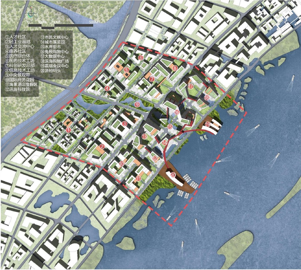
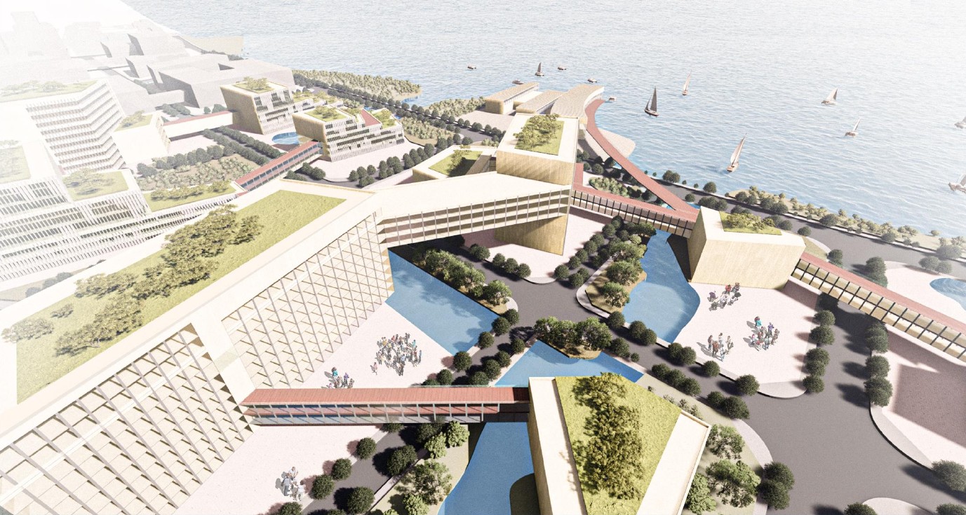
The final output translates the research and strategy into a complete plan for approximately 125 hectares. The masterplan organises twenty major programme nodes and is supported by land-use allocation, a road hierarchy, blue-green infrastructure, development intensity, and building-height controls. The proposal uses an overall floor-area ratio of 1.50, building coverage of 22.4%, and a green-space ratio of 28.1. Building heights are grouped into four bands—below 20 metres, 20–30 metres, 30–50 metres, and 50–80 metres—and step down towards the waterfront to protect the coastal skyline. A central landscape belt and coastal promenade form a T-shaped ecological spine, supported by two C-shaped green corridors and neighbourhood-scale green nodes.
08
Process & evidence
Reflection and next steps: Moving from technological imagination to implementable smartness
In retrospect, the project’s strongest contribution is its attempt to place industry, housing, mobility, landscape, ecology, and infrastructure within one spatial framework. Its limitations are equally important. The research appears to rely mainly on planning documents and secondary information; the submitted material does not document local stakeholder interviews, resident-needs testing, ecological baselines, coastal engineering calculations, phased investment, or an operating institution. Proposals such as facial recognition, drone surveillance, and digital twins also reflect a technology-forward optimism that now requires closer scrutiny of privacy, equity, governance, and maintenance costs. A credible next phase would validate the needs of users, industries, and public institutions; model flooding and storm surge; assess ecological impacts; test infrastructure capacity and costs; and translate each technology into an implementation plan with accountable owners, data boundaries, maintenance arrangements, and exit conditions.
Outcome & reflection
Why this project matters
This graduation project demonstrates my early ability to translate macro-level development questions into a site-scale planning system. It also revealed that “smartness” cannot be reduced to devices and technology; it must be tested alongside climate adaptation, public space, everyday mobility, resource governance, and implementation capacity.