Social media research · GIS data engineering · San Tin, Hong Kong · 2026-present
San Tin’s Digital Place Image: Cross-platform Heritage Research
A cross-platform study combining Google Maps reviews, Instagram posts and GIS audits to examine how San Tin’s rural cultural landscape becomes visible, overlooked and contested online.
01
Overview
Context and purpose
I developed an auditable cross-platform research workflow combining Google Maps reviews, Instagram posts and GIS/POI audits to examine how San Tin’s villages, farmland, fishponds, border mobility and everyday heritage become visible, overlooked or contested online. Rather than treating social media as a neutral archive, the project compares how each platform produces a different version of place and makes its omissions, boundaries and uncertainty part of the evidence.
My contribution
What I was responsible for
- 01
Built a versioned evidence chain from raw exports through cleaning, deduplication and coding to visualisation, retaining data dates, inclusion rules, manifests and audit samples.
- 02
Completed a 14-theme multi-label analysis of 738 unique text reviews across 15 Google Maps POIs, preserving sentiment, place-level differences and before/after changes.
- 03
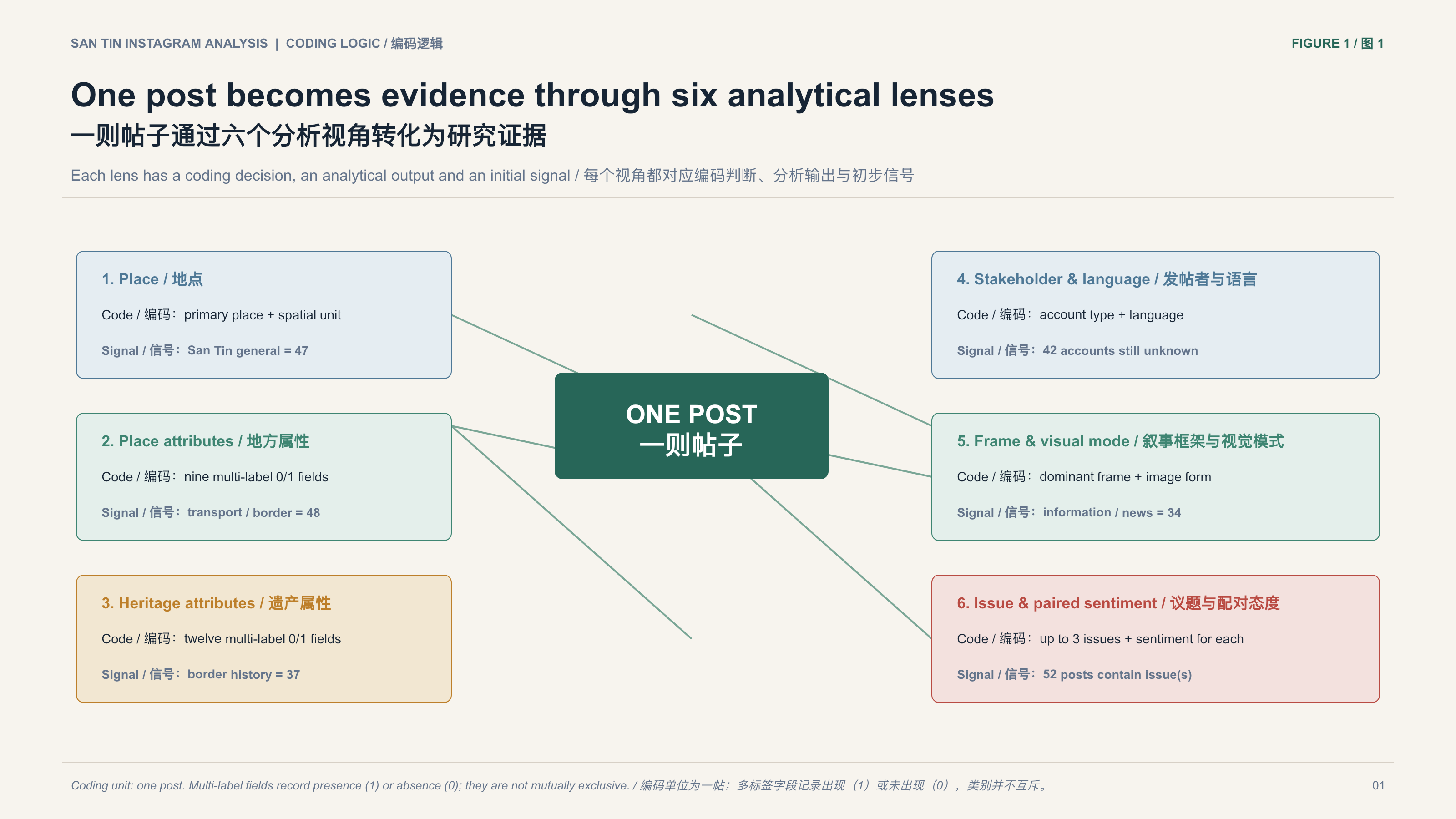
Curated 117 San Tin-relevant Instagram posts and used six analytical dimensions to interpret place, heritage, narrative and issue-specific sentiment.
- 04
Produced editable bilingual workbooks, GIS layers, six Google Maps charts, an eight-page Instagram figure pack and two bilingual preliminary reports.
- 05
Kept online visibility distinct from heritage value and documented sample bias, version differences and outstanding review.
02
Process & evidence
Context: reading a rural landscape through digital traces
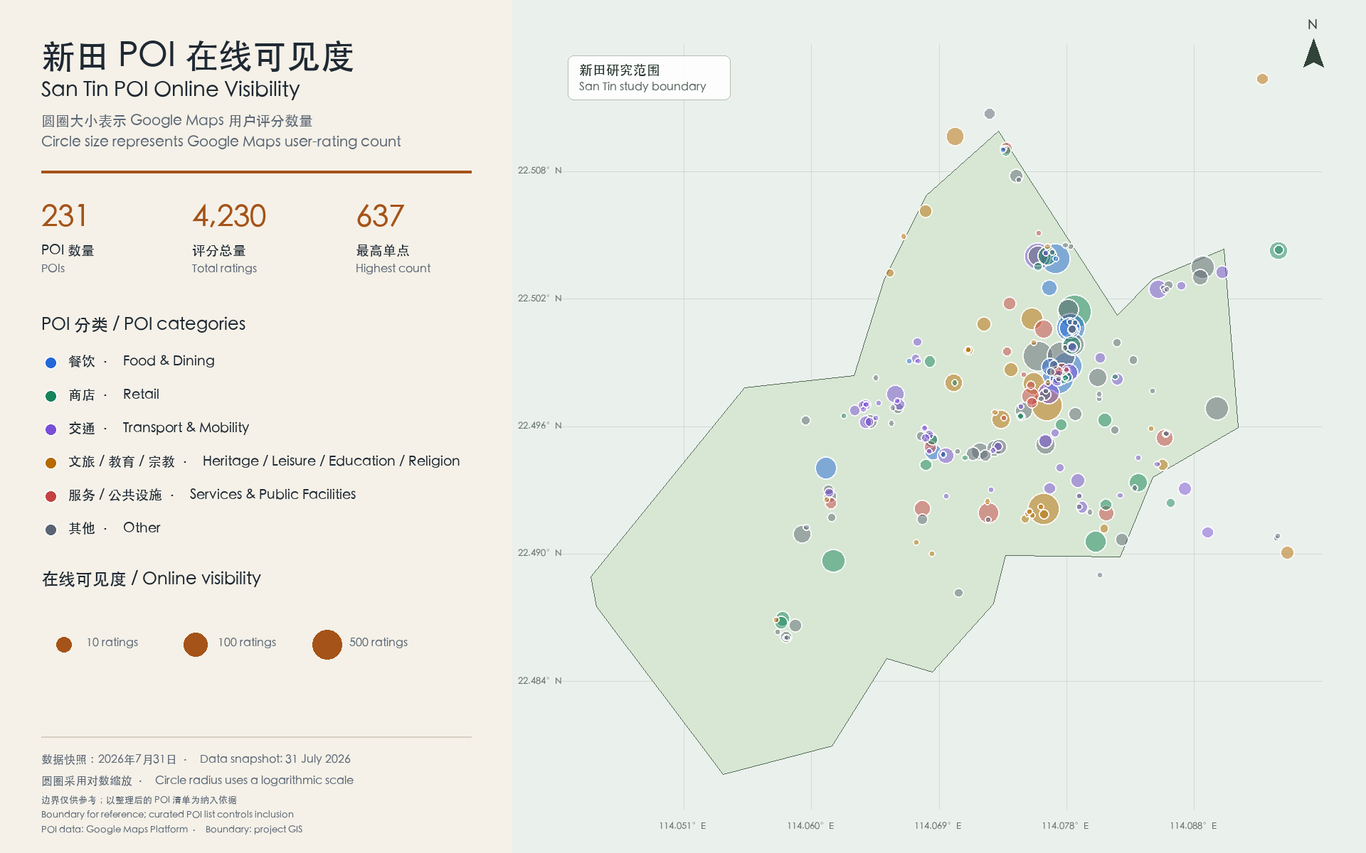
San Tin is simultaneously a landscape of villages, farming and fishponds, lineage and festival traditions, and a territory shaped by cross-border mobility, wetland conservation and large-scale development proposals. Conventional heritage inventories often begin with buildings, statutory status or expert value judgements. Social media leaves another kind of evidence: where people actually visit, how they describe access and facilities, what they recognise as scenery, memory or risk, and which places attract almost no digital voice. I framed the work as a digital–spatial study with three aims: to measure online visibility, interpret the heritage and cultural-landscape meanings within visible content, and audit the omissions and biases produced by platform data itself.
03
Process & evidence
From platform traces to reviewable evidence
The first challenge was platform constraint. Google Maps reviews were assembled through manual loading, browser export and POI-level file organisation. Instagram collection began with #santin and #新田, repeatedly loading visible posts until four consecutive rounds produced no new records. Because “新田” can also refer to a person, another place or a Japanese-language context, scraped results were never treated as the study sample by default. Raw CSV/JSON exports were preserved, permalinks normalised, collection rounds merged, duplicates removed and false-positive exclusions retained. Publication dates were separated from first-seen timestamps, while Google Maps records retained their source POI, original text and cleaning status. The workflow converted data that could be collected into evidence that could be interpreted, challenged and checked again.
04
Process & evidence
Google Maps: how visit experience shapes place image
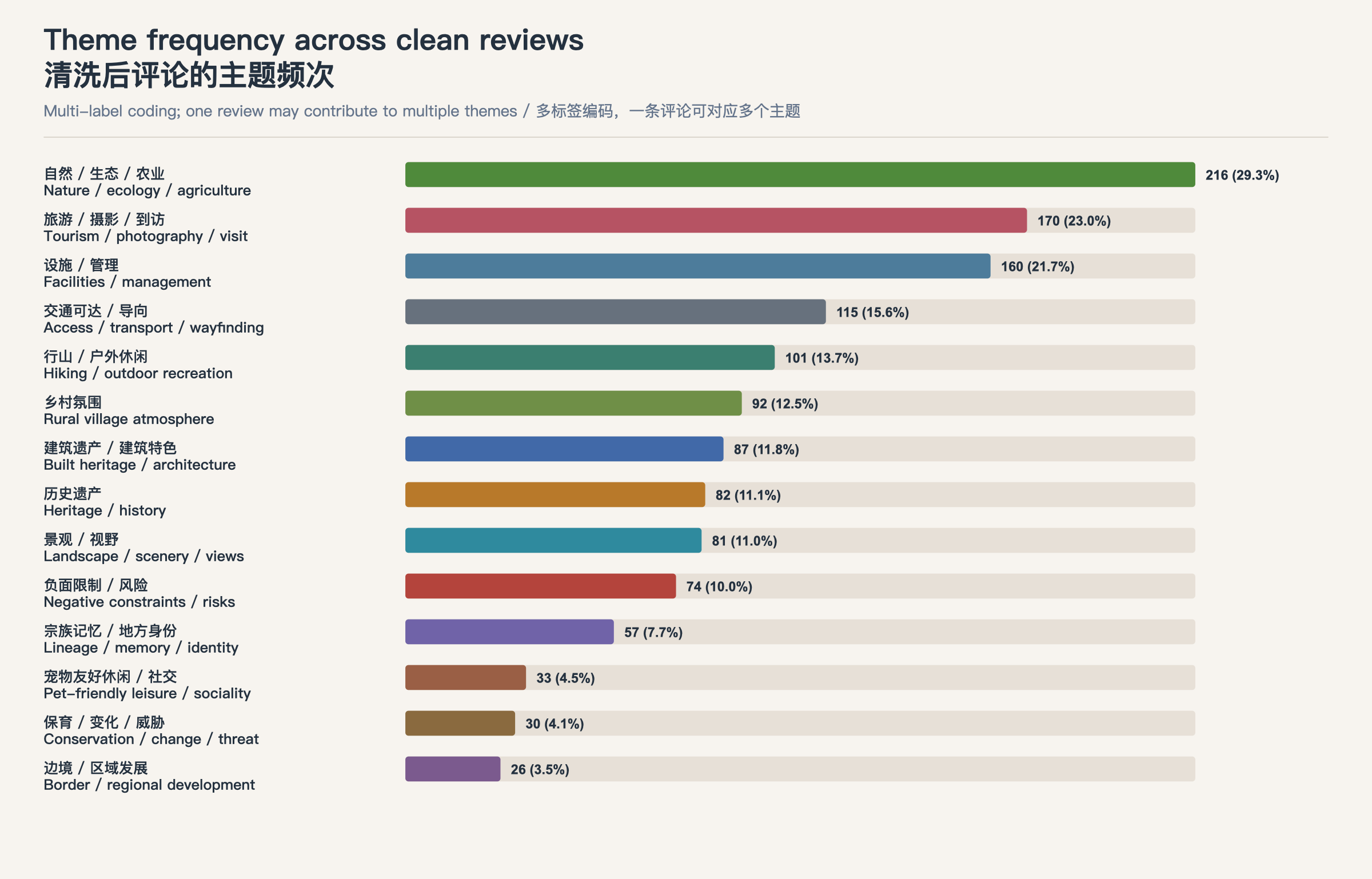
The current analysis covers 738 cleaned and unique text reviews across 15 POIs and 14 themes. Nature, ecology and agriculture is most frequent (216 reviews, 29.3%), followed by tourism, photography and visiting (170, 23.0%) and facilities and management (160, 21.7%). A total of 506 reviews are positive and 33 positive with constraints, together about 73.0%. The sample is highly concentrated: Shun Sum Yuen Farm, Tai Fu Tai Mansion and Man Tin Cheung Park contribute 595 reviews, or 80.6%. Heritage meaning is also place-specific. Tai Fu Tai concentrates architectural, historical and conservation narratives; Man Tin Cheung Park connects history, lineage memory and recreation; Shun Sum Yuen is dominated by agriculture, tourism, facilities and nature experience. A later pet-leisure venue changed both the codebook and theme shares, demonstrating why version history is part of the research.
05
Process & evidence
Instagram: relationships, events and ongoing change
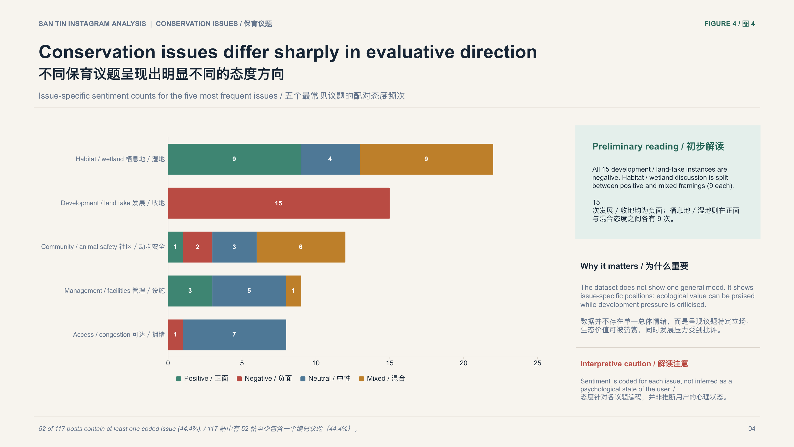
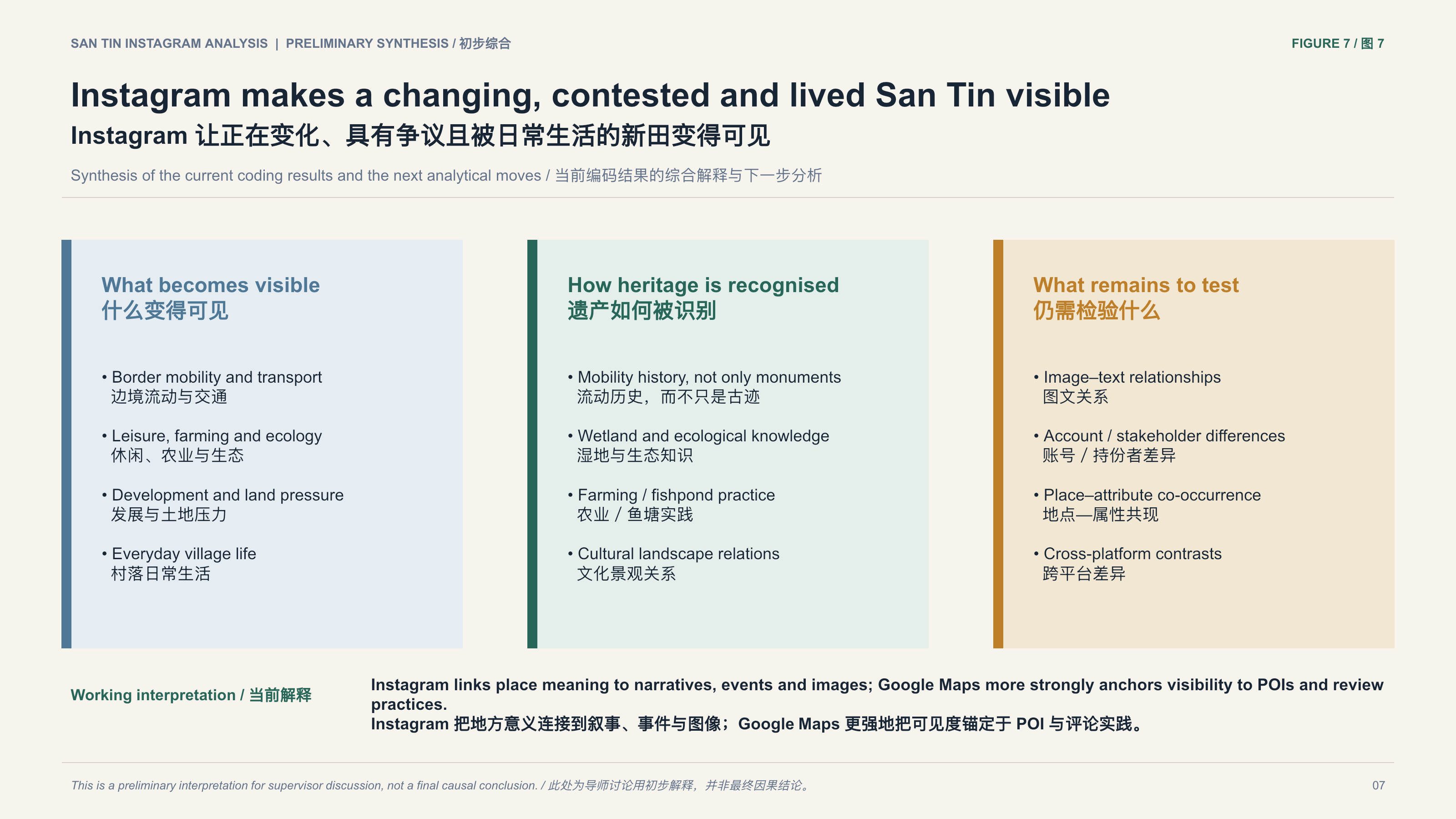
The Instagram sample retains 117 San Tin-relevant posts published between 2016 and 2026. The most frequent attributes are transport and border mobility (48 posts, 41.0%), leisure and tourism (40, 34.2%), planning and development (39, 33.3%) and community life (37). Heritage attributes extend beyond monuments: border and mobility history appears 37 times, wetland and ecological knowledge 20, farming and fishpond practice 19, and everyday village life 18. Fifty-two posts (44.4%) contain at least one conservation issue. All 15 development or land-take instances are negative, while habitat and wetland discussion divides between supportive and mixed positions. “San Tin” as an area appears in 47 posts—more than any individual venue—making a changing, contested and lived landscape visible.
06
Process & evidence
Cross-platform interpretation without false equivalence
Raw counts from Google Maps and Instagram should not be compared directly. Google Maps is organised around place pages, visits and service experience; Instagram around accounts, posts, images, events and narratives. Their collection mechanisms, ranking logics, time ranges and user populations differ. I therefore completed codebook development and quality control within each platform before aligning concepts at a higher level. The most defensible synthesis is that Google Maps anchors visibility to locatable POIs, access and facilities, while Instagram links place meaning more readily to areas, images, events, news, development pressure and everyday relationships. The result is not a master ranking but a framework for understanding how platforms produce knowledge about place.
Outcome & reflection
Why this project matters
The project shows how fragmented platform traces can become auditable cultural-landscape evidence without treating ratings, review counts or hashtag visibility as heritage value. More importantly, it demonstrates that different platforms produce different versions of San Tin, and that cross-platform comparison must make omissions, boundaries and uncertainty visible.