Team Lead · Conservation Management Studio · HKU · 2025
Walking the Living Legacy: Tung O Ancient Trail
A values-led conservation management plan for the approximately 13-kilometre historic route between Tung Chung and Tai O, translating heritage, settlement, ecology, access and community evidence into policies, visitor strategies, monitoring and phased action.
01
Overview
Context and purpose
The plan treats the trail as a living cultural corridor rather than an isolated path. It connects condition and historical-change evidence with differentiated village roles, conservation policies, access, interpretation, community governance, climate resilience and long-term monitoring.
My contribution
What I was responsible for
- 01
Led the team and the conservation-management workstream, shaping the research structure and integrating the final management narrative.
- 02
Produced most or all of presentation panels 1, 2, 4, 5 and 6, covering site mapping, condition assessment, strategy, policies, visitor management and the San Tau pilot.
- 03
Developed GIS and historical comparisons of protected areas, agricultural land, settlement extent and demographic change, including 1963-2024 agricultural land and 1973-2025 village-area comparisons.
- 04
Led the regional policy, visitor zoning, access, interpretation, monitoring and People-Planet-Prosperity action frameworks.
- 05
Contributed to the significance work, risk and stakeholder analysis, proposed-use strategy and Heritage Impact Assessment, including sections formally recorded as 2.2, 4.1 and 4.3.
02
Process & evidence
A living corridor between Tung Chung and Tai O
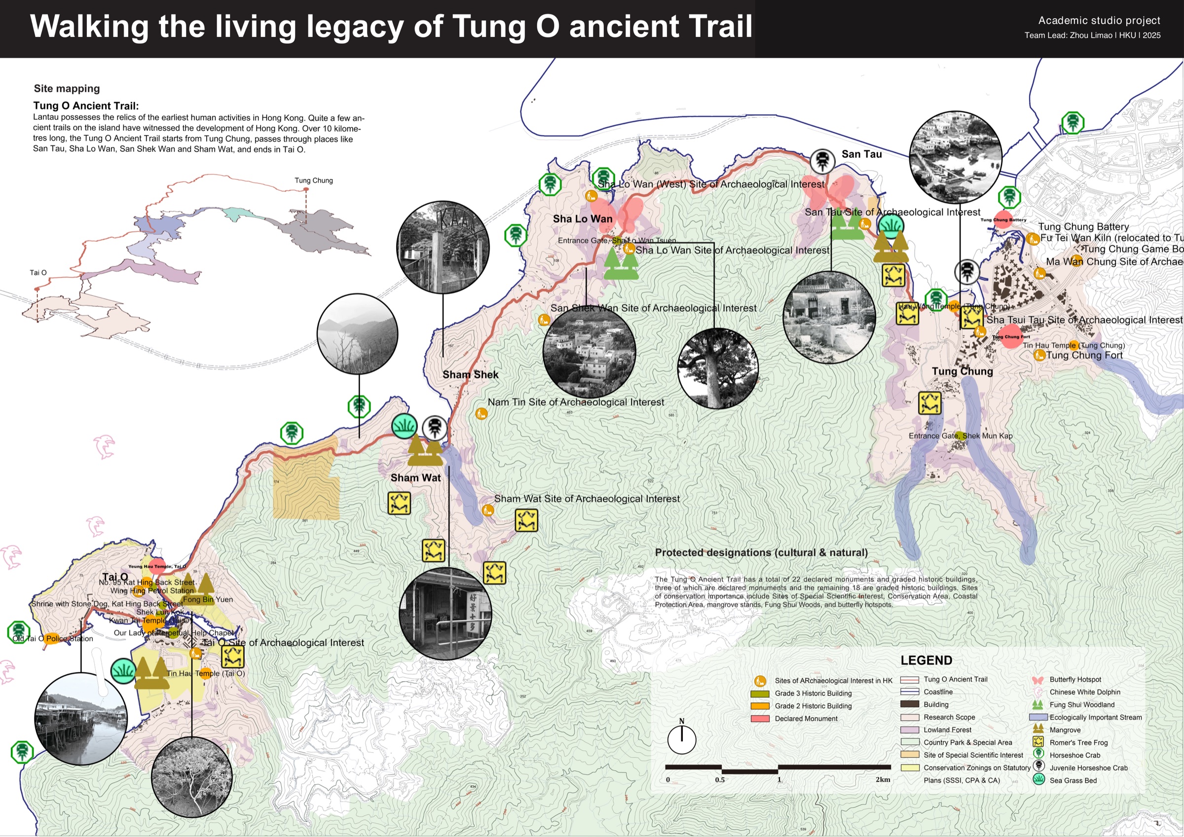
The Tung O Ancient Trail links Tung Chung and Tai O through San Tau, Sha Lo Wan, San Shek Wan and Sham Wat. It is not only a walking route: historic land-and-sea mobility, village life, farming and fishing, religious places, archaeology, coastal landscapes and ecological systems overlap along the corridor. The studio therefore framed the site as a living landscape whose tangible and intangible relationships must be managed together.
03
Process & evidence
Growth at the ends, contraction in the middle
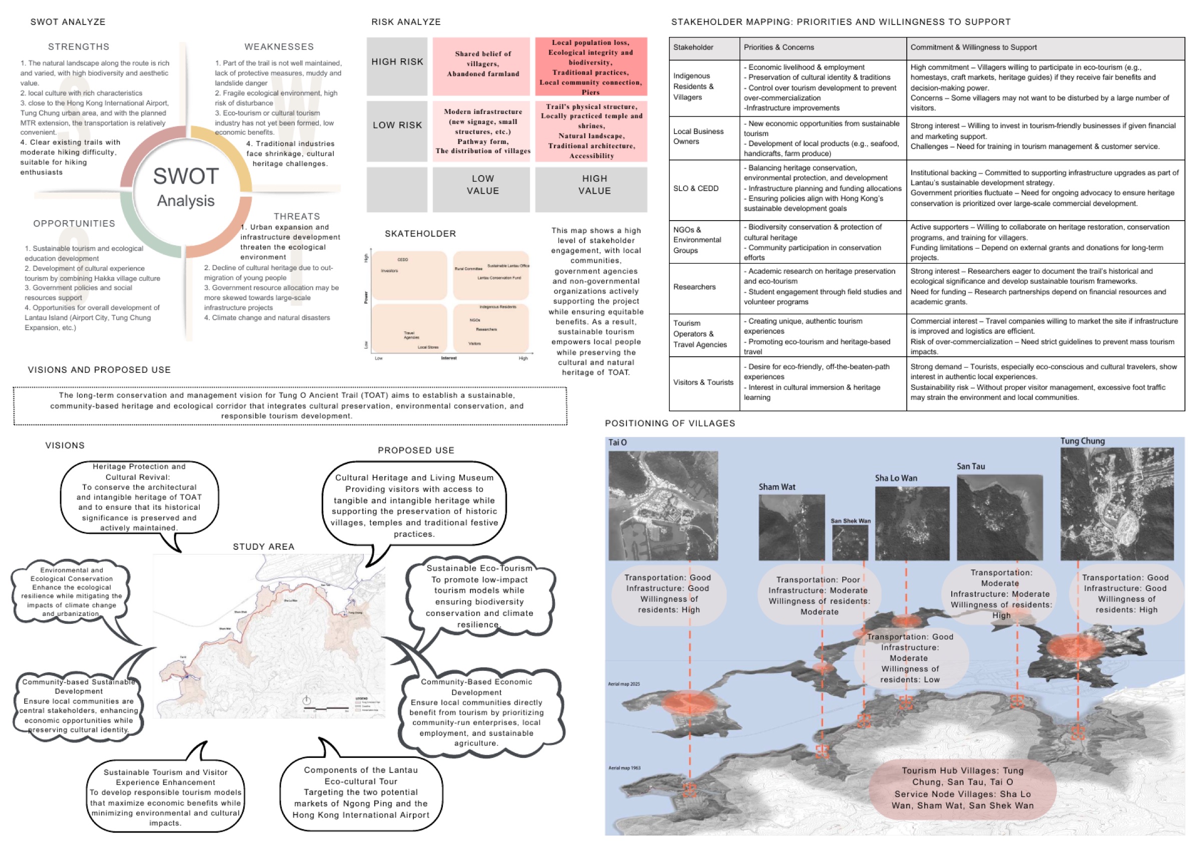
Tung Chung and Tai O continue to develop at the two ends of the trail, while several intermediate villages face population loss, reduced farming, declining traditional livelihoods and limited everyday services. Tourism, infrastructure pressure, poorly maintained trail sections, extreme weather, ecological disturbance and commercialization add further risk. The challenge was not to turn the entire route into one tourism product, but to support differentiated forms of protection, access and village continuity.
04
Process & evidence
Leading the management workstream
As team lead, I shaped the research structure and led the progression from evidence to management decisions. My work included the study boundary, significance research, condition and pressure assessment, GIS change analysis, stakeholder and risk work, policies and zoning, visitor management, interpretation, monitoring, sustainability actions and Heritage Impact Assessment.
05
Process & evidence
Building a spatial evidence base
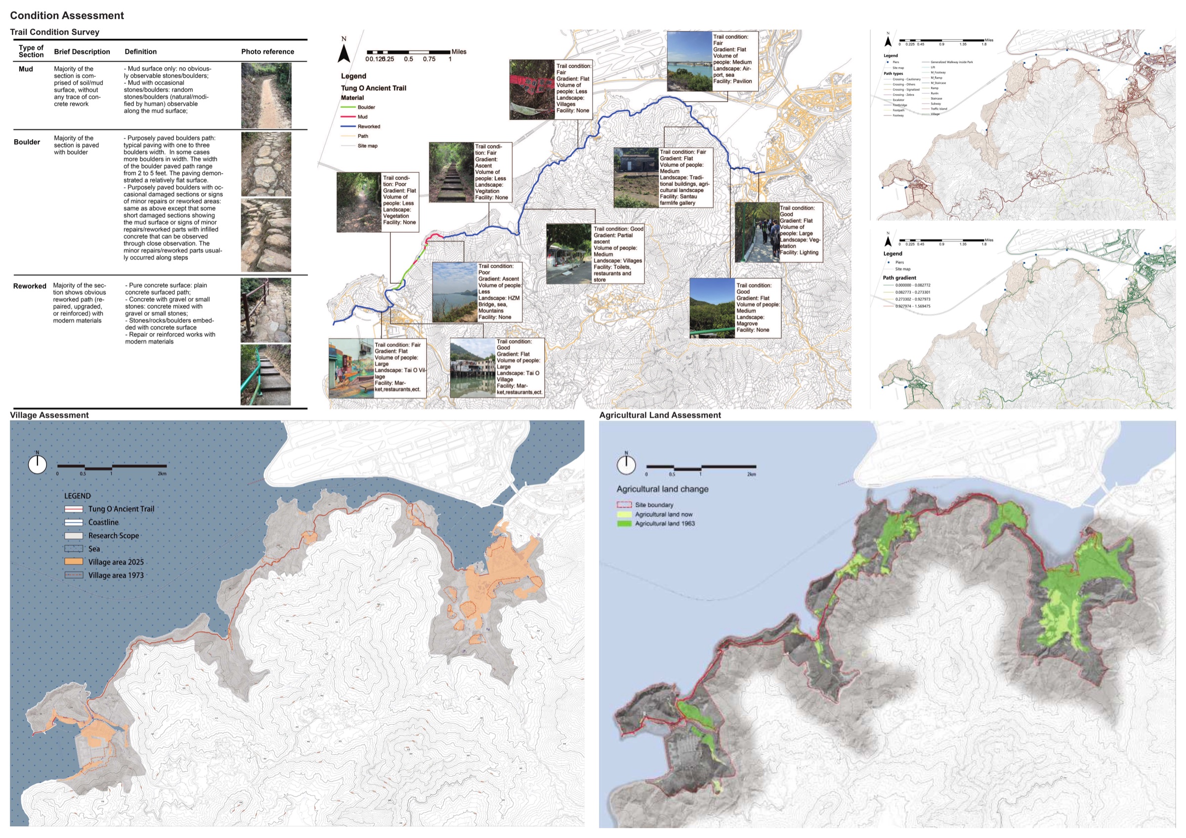
The study followed a values-led process informed by the Burra Charter and conservation-plan methodology. Documentary research, policy review, site-inspection material, existing oral-history studies, historical maps, aerial imagery, demographic data and GIS layers were read together. The condition survey distinguished mud, boulder and later concrete-reworked trail sections, while historical comparisons traced agricultural, settlement and demographic change across the corridor.
06
Process & evidence
From evidence to differentiated policy
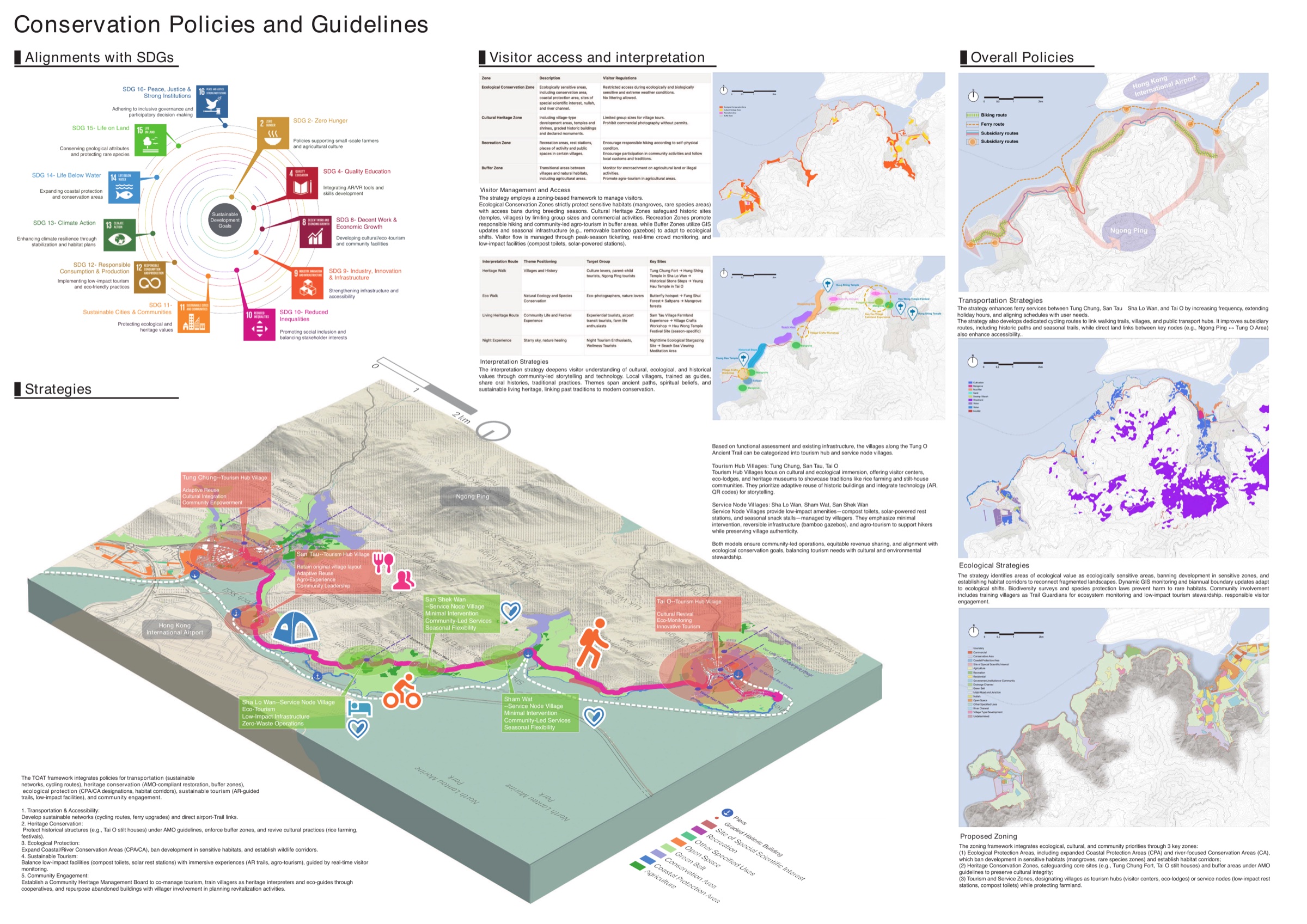
The final framework grouped management decisions across transport and connectivity, built heritage, ecology, sustainable tourism, community participation, and adaptive reuse and village revitalization. Conservation buffers, ecological nodes, trail maintenance, ferry and slow-mobility connections, differentiated village roles and low-impact facilities created a corridor-wide strategy without applying the same level of intervention everywhere.
07
Process & evidence
Visitor management, access and interpretation
The visitor framework proposed ecological conservation, cultural heritage, recreation and buffer zones, each with different capacity, behaviour and facility principles. Measures included sensitive-period restrictions, peak-season reservations, low-impact rest facilities, community guiding, dynamic signage and monitoring through visitor counts, patrols, ecological records and community feedback. A Walking the Living Heritage interpretation theme linked road memory, human-nature relationships, beliefs and the future of living heritage across physical and digital routes.
08
Process & evidence
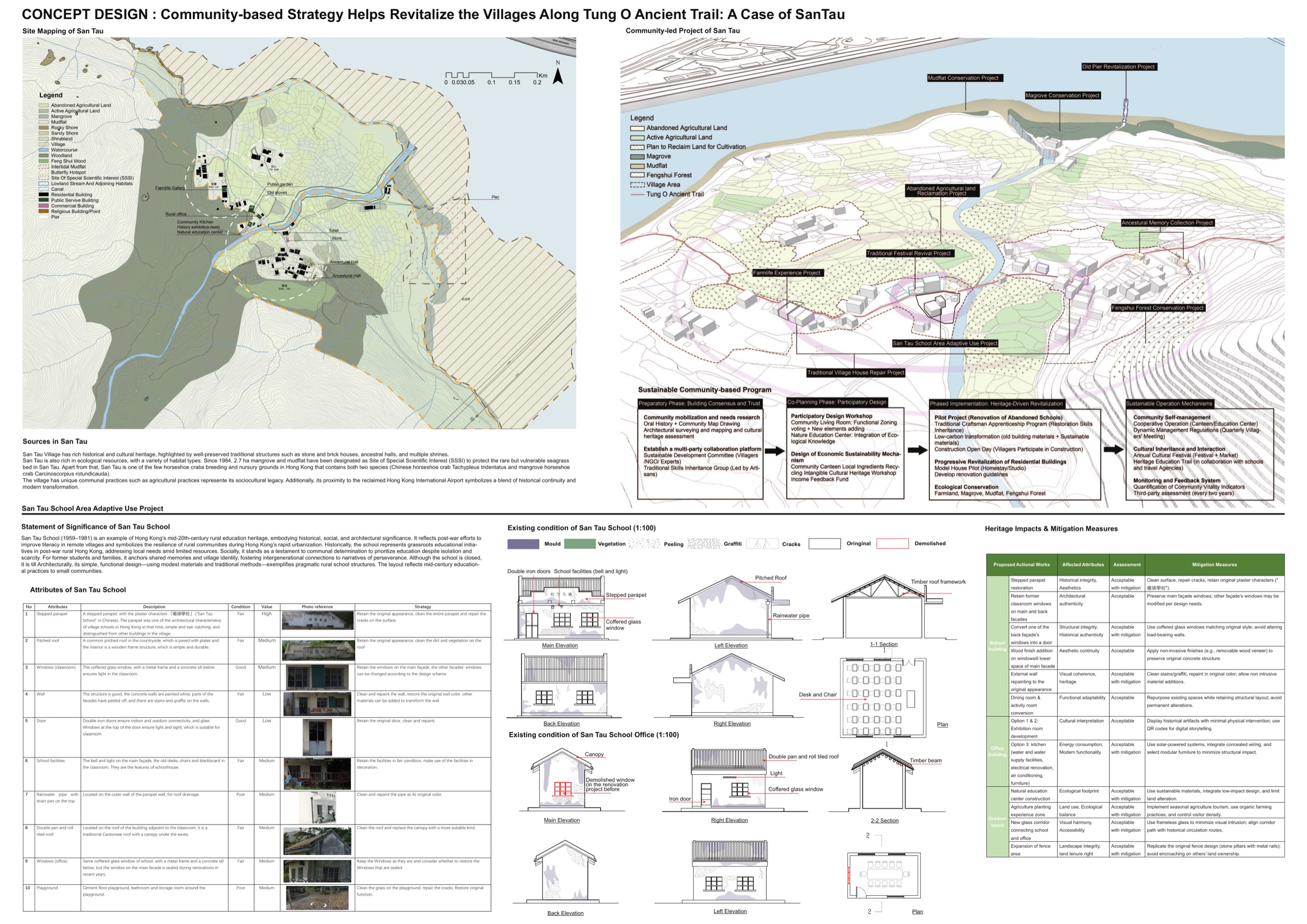
Testing the framework at San Tau
San Tau was selected as a pilot for connecting corridor management with site-specific intervention. The proposal phased community needs and consensus building, participatory design, school reuse and skills transmission, cooperative operation, funding and risk management. The Heritage Impact Assessment linked proposed changes at the former school with retention of significant attributes, reversible and minimal intervention, mitigation, monitoring and delivery responsibility, while retaining residual risks such as maintenance burdens and functional drift.
09
Process & evidence
Implementation logic and limitations
People, Planet and Prosperity organized the social, environmental and economic actions, with proposed governance, community stewardship, ecological and climate monitoring, cooperative operation and local value chains. The project is an academic proposal rather than an implemented programme: its partnerships, capacities, schedules and quantitative targets require further validation, and the materials do not establish completed community co-design, systematic visitor counts or a long-term ecological baseline.
Outcome & reflection
Why this project matters
The project demonstrates how conservation management can connect heritage values, community life, ecology, mobility, responsibility and monitoring across scales.